Bordeaux in 3D: the city from above
When you don't know a city, the hardest part is understanding how it fits together: where the river is, where the old districts are, what you can do on foot. We built a 3D model of Bordeaux from the Métropole's aerial photographs and placed on it every spot we recommend to our guests. Explore it to plan your stay, or keep it handy once you are here.
Works on computer, tablet and phone. The map is in French.
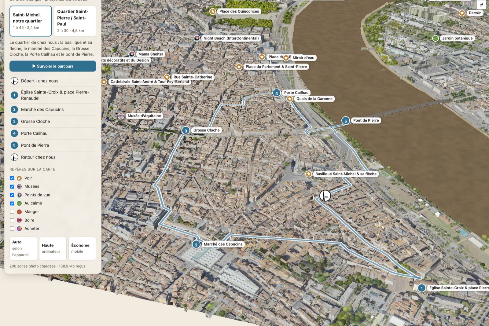
What you can do on the map
- Turn around the city, zoom in on a district, find the river and the bridges.
- Show our addresses by theme: sights, museums, viewpoints, quiet spots, restaurants, bars, shops.
- Click on a place to read our take on it and open its page.
- Follow our two walks step by step, with an animated fly-over of the route.
How Bordeaux is laid out
Bordeaux stretches along a wide bend of the Garonne, the “Port of the Moon”. Almost everything visitors come to see lies on the left bank, between the river and the boulevards.
Saint-Michel and Sainte-Croix, our neighbourhood
South of the centre, around the Saint-Michel spire. A lively, down-to-earth district: the Capucins market, the flea markets on Place Meynard, terraces facing the basilica. A little further on, along rue Camille-Sauvageau, the square in front of Sainte-Croix church and the TnBA theatre, with quiet terraces away from the traffic. This is where our B&B is.
The historic heart
Between Saint-Michel and the Grand Théâtre: the narrow streets of the Saint-Pierre district, the Porte Cailhau, Place du Parlement, then Place de la Bourse and its Water Mirror by the river. Further west, Saint-André cathedral, the Pey-Berland tower and the Palais Rohan. Rue Sainte-Catherine, a long pedestrian shopping street, ties it all together.
The Garonne quays
A long promenade along the river, on foot or by bike, in front of the 18th-century façades. It links Saint-Michel to the south, the Water Mirror in the centre and the Chartrons to the north. The Pont de Pierre leads across to the right bank.
Chartrons and Bacalan, to the north
The old wine merchants' district, then the wet docks: the Cité du Vin, the submarine base, the Mer Marine museum and the Chaban-Delmas lift bridge. Along the way, the CAPC museum and the Jardin Public.
The right bank
Greener and quieter, with the best view of the left-bank façades. Here you will find Darwin, a former barracks turned alternative venue, the botanical garden and riverside open-air bars.
All our addresses on the map
Each address below opens directly on the map (📍). Those with their own page are underlined.
Sights
- Place des Quinconces 📍
- Grand Théâtre 📍
- Palais Rohan 📍
- Saint-André Cathedral & Pey-Berland Tower 📍
- Rue Sainte-Catherine 📍
- Place du Parlement & Saint-Pierre 📍
- Place de la Bourse 📍
- Porte Cailhau 📍
- Grosse Cloche (Big Bell) 📍
- Saint-Michel Basilica & its spire 📍
- Capucins Market 📍
- Pont de Pierre (Stone Bridge) 📍
- Submarine Base 📍
- Darwin 📍
- Garonne Riverbanks 📍
- Pont Chaban-Delmas 📍
- Sainte-Croix Church & Place Pierre-Renaudel 📍
Museums
Viewpoints
- Miroir d'eau (Water Mirror) 📍
- Wallace Bar (Radisson Blu) 📍
- Night Beach (InterContinental) 📍
- Mama Shelter 📍