By Cécile — September 2026 — 4 min read
When you are planning a stay in a city you do not know, lists pile up fast: the landmarks to see, the restaurants you have spotted, the tips from friends. What is missing is the overview. Where is the river? What is near what? What can be done on foot, and what deserves a tram?
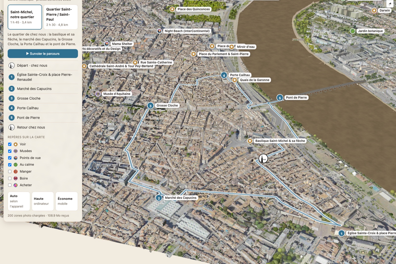
To answer these questions, we built a 3D map of Bordeaux, from Bordeaux Métropole's aerial photographs, and placed on it every spot we recommend to our guests. Here is how to use it to plan your stay, then to find your way once you are here.
Start with the river
Bordeaux makes sense once you start from the Garonne. The city grew along a great curve of the river, shaped like a crescent moon, hence its nickname "port de la Lune" (port of the Moon). On the map, rotate the view and follow that curve: almost everything worth seeing sits on the left bank, between the river and the grand boulevards.
The quays are the city's connecting thread. They link the Saint-Michel district in the south, place de la Bourse and its water mirror in the centre, then the Chartrons and the docks to the north. Once you have that landmark in mind, everything else falls into place on its own.
The neighbourhoods, seen from above
Flying over the model, several distinct Bordeaux come into view:
- Saint-Michel and Sainte-Croix, south of the centre, recognisable by the Saint-Michel spire towering over the rooftops. A lively, working-class neighbourhood, with its market, its flea markets and its terraces. This is where our guesthouse is.
- The historic heart, a maze of narrow streets around the porte Cailhau and place du Parlement, opening onto place de la Bourse, then the cathédrale Saint-André and the palais Rohan.
- The Chartrons and Bacalan, to the north, with the Cité du Vin, the submarine base and the Chaban-Delmas lift bridge.
- The right bank, greener and quieter, offering the finest view of the left bank's façades.
We describe each of these neighbourhoods on our Bordeaux in 3D page, with a direct link to the right spot on the map.
Choosing where to eat before you leave
This is probably the map's most useful feature. In the "Map markers" panel, tick Eat or Drink: all our addresses appear, placed exactly where they are. You can see at a glance which ones are steps from a landmark you plan to visit, and which ones cluster together in the same corner — handy for a drink followed by dinner without hopping back on the tram.
One example: tick Drink, and you will see that the small square in front of the église Sainte-Croix and the TnBA theatre gathers several terraces, quiet, away from the traffic. You reach it on foot from Saint-Michel via rue Camille-Sauvageau. It is one of our favourite spots for the end of the day.
Click on an address: its card opens with our opinion, and sometimes a photo and a link to a more detailed page.
Try a walk before you take it
We have mapped two walking routes from our guesthouse: the historic heart and Saint-Michel and the quays. On the map, choose one of the two, then press "Fly over the route": the camera follows the itinerary street by street, pausing at each stop long enough to read the card.
In a few minutes, you know what the walk looks like, where it goes and what you will see along the way. When the day comes, you walk with an easy mind.
Once you are here: the map in your pocket
The map also works on your phone. Keep it open during your stay: it helps you place yourself in relation to the river and the landmarks, far better than a flat plan.
On our website, every place we recommend also carries a small 📍: it opens the map directly on that spot. You read an article, an address catches your eye, one click and you see where it is.
And where to sleep?
On the map, our house is always visible, at the foot of the Saint-Michel spire. You will see it is well placed: within walking distance of the river, the Capucins market and the historic heart, in a genuine neighbourhood where life is lived the Bordeaux way.
To plan the rest of your stay, see also our Discover Bordeaux page.